
RoadSense360™
All-Weather Multi-Modal Perception Platform for ADAS/ADS/AV Solutions
The Need
The path to deploying safe and effective advanced driver assistance systems (ADAS), automated driving systems (ADS), and autonomous vehicles (AVs) is fraught with challenges rooted in the lack of high-quality, comprehensive, synchronized, and multi-modal sensor data. Development teams face a persistent pain point of acquiring reliable multimodal datasets that accurately represent real-world driving conditions under diverse scenarios, weather, lighting, and traffic dynamics. Without such data, AI/ML models are prone to poor generalization, reduced robustness, and an inability to detect and respond to edge cases leading to unsafe or unreliable system behavior. Most available road data acquisition tools are piecemeal solutions such as single cameras, loosely integrated sensor suites, or prototype hardware that lack proper synchronization, are prone to data loss, or cannot withstand the rigors of real-world driving. As a result, ADAS/ADS/AV research and development (R&D) teams often spend excessive time on low-level integration tasks, fighting with timestamp misalignments, insufficient metadata, or equipment failure due to inadequate environmental protection. This significantly delays the development timeline, increases project risk, and misses the market opportunity. Additionally, sensor data often comes without adequate geospatial and inertial context. Without accurate GPS and IMU data fused with each image frame, it's nearly impossible to perform tasks like trajectory reconstruction, real-time localization, or map annotation. Even when GPS and IMU units are available, many systems lack the software infrastructure to align and visualize these data streams coherently, making analysis, labeling, and algorithm training laborious and error prone.
An often-overlooked pain point is the lack of onboard processing and annotation capabilities. Teams typically need to offload massive volumes of raw video to data centers for pre-processing and data labeling, which is time-consuming and expensive. Without edge AI capabilities, there's no real-time feedback or rapid iteration cycle, and valuable driving hours may be lost due to improperly configured or underperforming systems. Lastly, a very few generally available commercial or research-grade platforms exist with an all-in-one solution with robust, weatherproof enclosures suitable for long-duration vehicle deployments across varying terrains and climates. The absence of such a system hampers scalability, limits deployment flexibility, and increases maintenance overhead.
As regulatory bodies and safety standards demand increasingly rigorous validation of autonomous systems, the demand for high-quality multimodal datasets will continue to rise. In short, the current fragmented ecosystem of road data acquisition tools forces developers and researchers to build bespoke solutions, troubleshoot avoidable hardware/software issues, and invest disproportionately in system integration. This diverts valuable resources away from core innovation and slows progress toward safer, more intelligent driving systems. There is a clear and urgent need for a unified, reliable, and extensible platform that eliminates these pain points thereby enabling teams to focus on building, training, and deploying smarter automotive technologies.
Our Solution
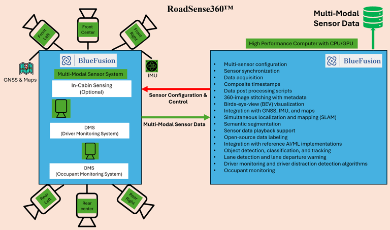

Figure 1: BlueFusion Multi-Modal Sensor Data Platform & Reference Software Implementation
To address the growing demand for reliable, high-fidelity data essential to the development of ADAS, ADS, and AV systems, we present RoadSense360™, a robust and highly integrated road data acquisition platform. RoadSense360™ combines advanced multi-camera imaging, precision GPS/IMU sensors, and powerful edge computing into a unified, vehicle-mounted system designed for seamless deployment in real-world driving environments.
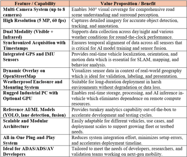
At the heart of RoadSense360™ is a ruggedized enclosure housing up to 8 high-performance cameras, each capable of capturing 5-megapixel images at up to 60 frames per second, effectively capturing 2.4 Gigapixels per sec. These cameras are equipped with both visible and infrared imaging modalities, ensuring optimal performance across varied lighting and weather conditions, whether operating under full sun, nighttime, fog, or rain. Frame-level synchronization is ensured across the cameras to enable time-aligned multi-view capture critical for perception algorithms, sensor fusion, and 360-degree situational awareness on the road.
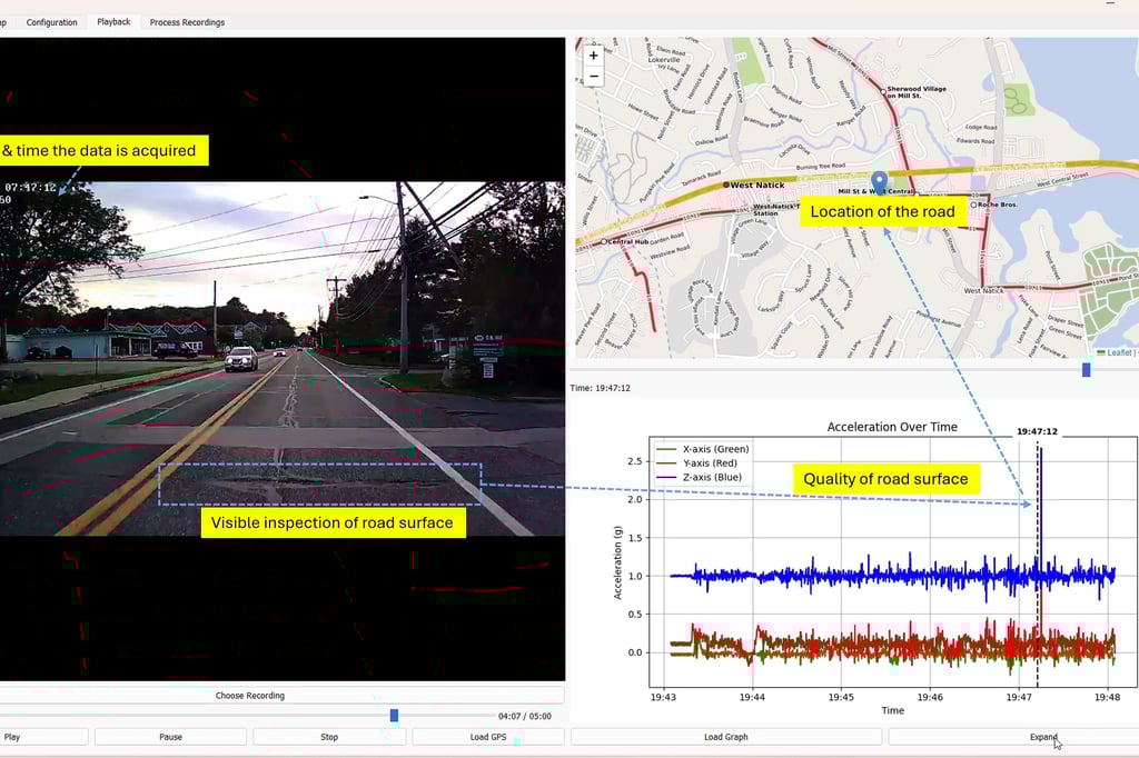
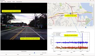
Our sensor suite includes tightly integrated GPS and IMU modules that provide real-time data on vehicle position, velocity, orientation, and acceleration. Every frame of visual data is time-stamped and spatially tagged, ensuring seamless fusion across sensor modalities. This synchronized multimodal dataset enables downstream applications such as Simultaneous Localization and Mapping (SLAM), trajectory reconstruction, and inertial navigation system validation. One of the key differentiators of RoadSense360™ is its real-time integration of camera, GPS, and IMU data onto geographic mapping layers, such as OpenStreetMap. As the vehicle moves, captured data is dynamically overlaid onto a map, providing a visual and spatial context for every detected object and scene element. This feature enables developers to visualize driving behavior, object interactions, and road semantics in real time or during post-processing which greatly simplify labeling, debugging, and AI/ML model training.
The entire system is powered by an industrial-grade high-performance computer (HPC) that is purpose-built for vehicular environments. RoadSense360™ includes high-capacity solid-state storage for extended recording sessions and offers optional GPU acceleration for on-device AI inference. This allows developers to run reference AI models such as YOLO for object detection, deep neural networks for lane detection, and multi-camera fusion algorithms directly on the HPC during data collection. These capabilities reduce the need for costly, time-consuming post-processing and enable agile iteration of perception pipelines.
RoadSense360™ is more than a sensor suite. It is a complete data acquisition and perception development platform. It can be deployed out-of-the-box, minimizing integration time and maximizing data quality from the first drive. The weatherproof design, shock-resistant mounting system, and EMI-hardened cables ensure durability under challenging conditions, making the platform ideal for data collection in both urban and off-road environments. For ADAS solution providers, RoadSense360™ provides ground truth data necessary for validating object detection and tracking algorithms. For AV startups, RoadSense360™ supports the creation of robust training datasets across a range of scenarios and geographies. Research labs can use RoadSense360™ to study human-driver interaction, traffic dynamics, or road user behavior. Tier-1 suppliers and OEMs can integrate this system into their test fleets to accelerate development and compliance efforts.
In a field where data quality defines the ceiling of innovation, RoadSense360™ offers the clarity, precision, and reliability that ADAS/ADS/AV teams need to push boundaries. By capturing richly annotated, spatially aware, multimodal road data, we empower developers to build smarter, safer, and more capable driving systems today and into the future.
RoadSense360™ Enables Time Synchronous Acquisition of Camera, GPS, and IMU Data

Object Detection and 360 Vision using RoadSense360™ platform

Semantic segmentation with BlueFusion road data


High-Quality Data from RoadSense360™ Platform
RoadSense360™: Time synchronous spatial fusion and object detection


RoadSense360™: Lane Detection at Night
RoadSense360™: Daytime Lane Detection
Value Propositions of RoadSense360™
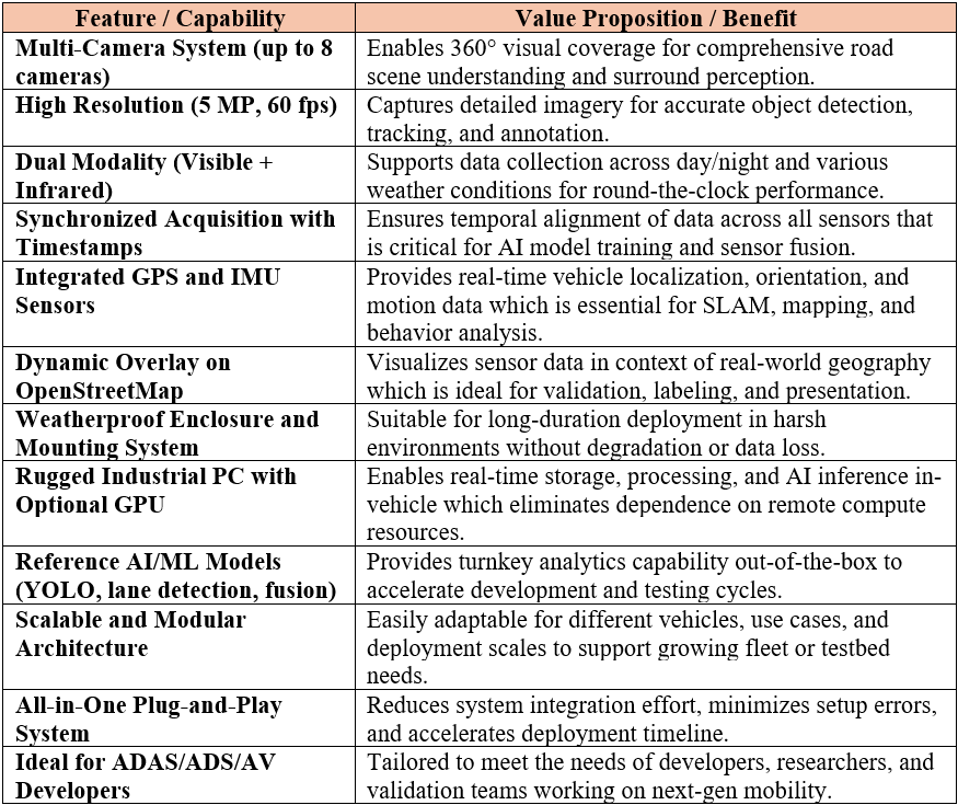
Comparison: RoadSense360™ versus Standalone Sensors
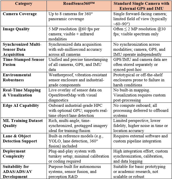
In summary, compared to a standard single-camera with GPS and IMU setup, RoadSense360™ offers synchronized, 360-degree high-resolution imaging with integrated visible and infrared modalities to enable rich, all-weather, panoramic data capture. Unlike basic systems that require post-processing to align sensor streams, our platform provides fine-grained synchronization and precise timestamping across all sensors. RoadSense360™ includes onboard computing with real-time AI/ML capabilities and OpenStreetMap integration, dramatically reducing setup time and improving operational efficiency. Designed for durability and scalability, RoadSense360™ is purpose-built for ADAS/ADS/AV development, delivering significantly higher data quality and system reliability.